The ingredients for the storm that will develop later today and tonight are a potent atmospheric river, strong southwest to westerly flow, and a warm front that will push through northern Utah tomorrow.
A great site for examining atmospheric rivers is the Atmospheric River Portal maintained by the Scripps Institute for Oceanography/UC San Diego. We'll take a look here at the GFS integrated water vapor transport forecasts from the GFS using graphics from their site. The forecast for 1800 UTC (1100 MST) today shows a corridor of strong integrated vapor transport extending from the eastern Pacific to the California. coast. The strongest transport, however, is still well upstream of the coast. Some weaker tentacles of stronger transport extend inland to the north and south of the High Sierra, but northern Utah is in an area of weaker transport that doesn't meet the threshold typically used to identify atmospheric river conditions (250 kg/m/s).
 |
| Source: http://mead.ucsd.edu/ |
 |
| Source: http://mead.ucsd.edu/ |
 |
| Source: http://mead.ucsd.edu/ |
 |
| Source: weather.utah.edu |
A quick look at the NAM shows it is putting out about 2 inches of water in the area around Ben Lomond Peak, Powder Mountain, and Snowbasin for the 24-hour period ending at 0000 UTC (1700 MST) tomorrow afternoon. This all suggests 2-3 inches of water equivalent is likely for that region, with potentially higher values at Ben Lomond Peak. Most of that precipitation will fall as wet, heavy snow, but temperatures climb enough tomorrow that snow levels could reach 7000-8000 feet tomorrow afternoon.
The numbers for Alta-Collins are lower. The NAM is going for 1.36" for the 24-hour period ending at 0000 UTC (1700 MST) tomorrow afternoon. The flow direction is an odd one as sometimes WSW Alta gets skunked a bit. My take is that 1-2" of water for upper Little Cottonwood probably makes sense for that 24-hour period. Some areas in the central Wasatch favored by SW flow may do better unless the moisture plume ends up a bit further north.
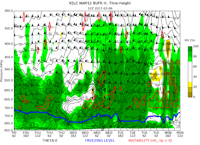
The situation for snow density is ideal for your classic upside down snowfall. Temperatures and snow levels are rising and water contents are likely going to be quite high tomorrow. Our alogirhtm is going for something like 14% water content (think Cascade Concrete) for tomorrow afternoon. I wouldn't be surprised if it is higher. Winds will probably maximize tomorrow afternoon as well. Note the strongest 700-mb (crest-level) winds in the time-height section below occur around 0000 UTC Wednesday (1700 MST tomorrow afternoon). That's about as strong of a flow as you'll see produced by this model at that level.
 |
| Source: weather.utah.edu |
There's a chance of more after tomorrow afternoon, but that is strongly dependent on how quickly the ridge builds upstream as discussed in the previous post. I'll tackle that tomorrow.

No comments:
Post a Comment