Most of the Salt Lake Valley enjoyed an exciting afternoon yesterday as a series of strong thunderstorms moved through the area.
As can be seen in the loop below, we were pretty fortunate (meteorologists like myself prefer consider it fortunate to be in bad weather). There were storms to the south and storms to the north, but in the strip from Dugway to the Salt Lake Valley, we were the most active area.
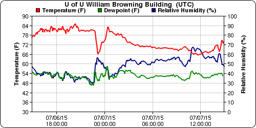
The storms generated an inch of rain in Riverton, which seems to be the big winner from this event. Here on the University of Utah campus, our weather station near the mouth of Red Butte Canyon recorded 0.37", which doesn't sound like much, but it fell in only 15 minutes, which is a pretty good rainfall rate for northern Utah. Really most of that rain fell in about a 5-10 minute period that can be described as either heaven or hell depending on your perspective. In addition to the heavy rain, winds gusted to 37 mph and the temperature dropped to 66ºF.
With the humidity higher than usual, the radar was able to pick up on a number of outflow boundaries produced by the thunderstorms. These can be seen in the loop above as lines of weak reflectivity that are often arc shaped. I've highlighted three examples from the middle of the period displayed above in the image below.
We will have to see if we are similarly lucky today, or if Mother Nature will favor other areas.


No comments:
Post a Comment