
 |
| Source: MesoWest |
As I suspected, the mini storm cycle has placed us firmly in hiker and skier purgatory. Enough snow to make hiking in the high country more difficult, but not enough for skiing (for most sane and rational people anyway – I know some of you are probably out already!). How will the scale tip in the coming days?
Both the ECMWF and the GEFS ensemble forecast systems suggest that ridging will dominate our weather through next weekend. There's a brush-by system on Tuesday and another late Friday, but currently most ensemble forecast members keep the precipitation to our north. In all likelihood, we'll make it through Sunday with little or no mountain snowfall. Lube the chain and hit the shoreline trail.
Desperate times call for desperate measures. Although I don't put much faith in extended range forecasts, a peak at the 8-14 day outlook from the Climate Prediction Center suggests that the odds favor warmth and dryness.
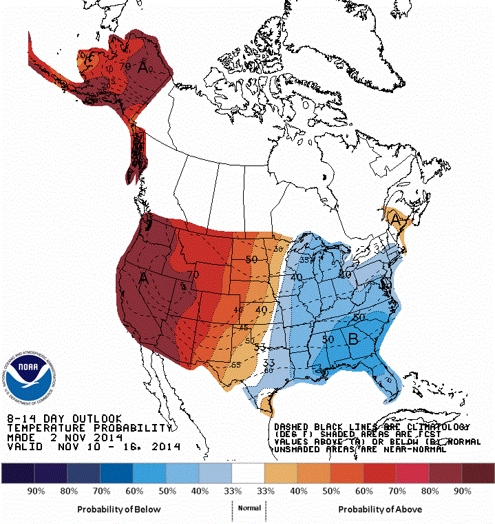 |
| Source; Climate Prediction Center |
 |
| Source: Climate Prediction Center |

Nuri is expected to undergo extratropical transition, converting into a midlatitude cyclone as it moves poleward (GFS forecast below), attaining great depth off the Kamchatka Peninsula.

The current minimum central pressure forecast from the GFS is a remarkable sub-920 mb. Yeah...920 mb! I had to adjust my contouring algorithm to deal with pressures that low.

I'm guessing there will be a big-wave surfing event in Hawaii thanks to the waves from this beast. Looking forward to watching it the next few days.
The lowest ET cyclone pressure ever record is 913 mb in 1993:
ReplyDeletehttp://www.wunderground.com/blog/weatherhistorian/super-extratropical-storms-alaska-and-extratropical-record-low-baro
The 126 hr 06Z GFS forecast had Niri at 914 mb!