
 |
| The ski season this spring has been quite a roller coaster. Source: http://www.telegraph.co.uk/news/newstopics/howaboutthat/5881002/Man-skates-down-roller-coaster.html |
Spring is known for ups and downs, but this spring has been especially interesting as we've had fluctuations from high amplitude ridges, accompanied by several days of warm sunny weather, to cold troughs that produce significant mountain snows.
As a result, the evolution of the snowpack in the central Wasatch this winter looks like one of those old wooden roller coasters with a long climb to great heights, followed by a series of drops and climbs.
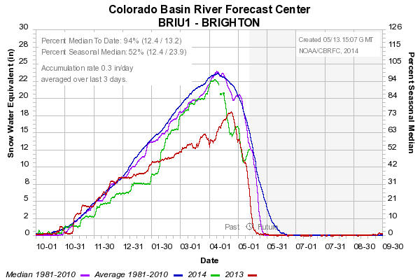
This is especially apparent at the Brighton and Thaynes Canyon (mid-mountain Park City) SNOTEL stations where peak snowpack snow-water equivalent (SWE) occurred in early April, but you can see two sharp recoveries following storms in late April and mid May (green line is this winter, red last winter, blue average, and purple median).
 |
| Source: NWS/CBRFC |
 |
| Source: NWS/CBRFC |
The Snowbird SNOTEL owing to it's slightly higher elevation and more north-facing aspect has nearly held steady over the past month.
 |
| Source: NWS/CBRFC |
At Alta-Collins (~9700 ft), the snow depth is currently 115 inches, very close to the maximum that was attained in late April and about as high as it has been all winter.
 |
| Source: MesoWest |
This is really the opposite of what you want. It's better to have more snow early and less snow late. But, those who have continued to venture to the mountains have found some surprisingly good skiing, and a lack of people.
No comments:
Post a Comment